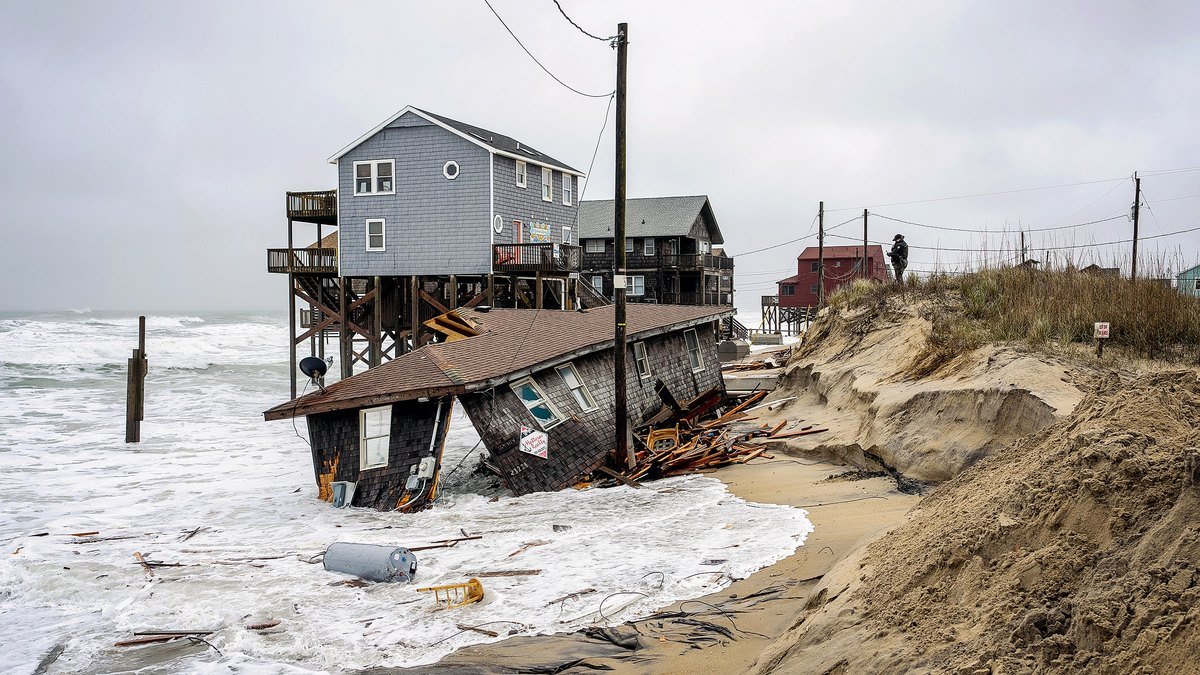
An early-season nor’easter is ravaging a stretch of North Carolina’s Outer Banks, where dozens of homes are already threatened by the encroaching ocean – and officials warn the next batch may not be long in coming
On Thursday, the Cape Hatteras National Seashore closed the beach from the northern edge of Rodanthe to the town’s pier because “several threatened oceanfront structures pose a threat to public safety,” it said National Park Service.
For locals, it’s an all-too-familiar scene. Since 2020, 32 houses have collapsed as the coastline has been repeatedly redrawn by erosion.
Losses were concentrated in Rodanthe and Buxton, two small villages on Hatteras Island, one of the narrow barrier islands that make up the Outer Banks.
At a state meeting last November, officials said they were tracking 100 threatened buildings in the two cities and warned that more could follow.
“If every single one of these structures collapses,” Cape Hatteras National Seashore Superintendent said Dave Hallac said“There would be another 100 right behind them.”
Years of erosion have led to more and more houses being pushed to the water’s edge
At least five other homes have already collapsed since Hallac’s warning, according to NPS records. And the latest storm is subjecting the remaining threatened properties to further punishment.
On Thursday, extreme flooding breached protective dunes on Pea Island, north of Rodanthe, damaging about 500 feet of pavement and forcing the closure of NC 12. The National Weather Service warned of breaking waves with a maximum height of 10 to 15 feet through Saturday evening.
The crashing surf hits a shoreline that looks completely different than when many of their beach houses were built.
Michael McDaniel bought his beach house in Buxton in 2011 for about $500,000, when about 250 feet – almost the length of a football field – of dunes separated his porch from the Atlantic Ocean.
But in the 15 years since, erosion has erased that buffer and made his home uninhabitable.
This retreat isn’t just limited to McDaniel’s property. The Outer Banks are barrier islands – narrow bands of sand that shift naturally as waves and currents move sand up and down the coast.
Erosion itself is part of this natural process.
In parts of Rodanthe, the shoreline has retreated an average of about 13 feet per year Dare County. In parts of Buxton, chronic erosion has historically exceeded 20 feet per year.
These long-term averages can also hide much more abrupt losses during bad weather.
For example, during Hurricane Erin in August 2025, 75 residential buildings in the two villages were damaged. Over the next two months, 16 homes collapsed during a series of offshore storms.
And as the coast moves inland, development is colliding with buildings constructed decades earlier. County records show that most of the homes now at risk were built in the 1980s and 1990s, when the ocean was much further away.
Homeowners are running out of options
Homeowners facing this slow-moving threat have few options.
While flood insurance typically covers direct property damage caused by flooding, it may not pay out just because erosion has put a home at risk.
“The NFIP policy pays for direct physical damage caused by flooding.” Lisa SharrardA North Carolina Flood Insurance Agent and Certified Floodplain Managertold Realtor.com®. “So there must be a flood event, not a normal flood.”
“The SFIP does not cover damage caused by gradual erosion,” adds Sharrard.
That can put homeowners like McDaniel in a difficult position: They’re stuck with a home that they may no longer be able to safely use, but that hasn’t yet suffered the damage that an insurance policy is designed to cover.
“If they have a policy, the policy may pay if the house collapses due to erosion,” Sharrard explains. “In the meantime, they have a house that they can no longer use and have to clean up the trash afterward. Most of them try to move when they can.”
Even with federal flood insurance in effect, the standard NFIP policy provides no more than $250,000 in buildings coverage for a single-family home—an amount that falls far short of what affected homeowners need.
A Rodanthe couple previously told Realtor.com that they spent more than $200,000 to move their home about 100 feet inland after erosion brought the sea dangerously close. And they had something many threatened homeowners don’t: There was enough land left behind the house to put it somewhere else.
Protecting the coast costs millions – and doesn’t last forever
So where does that leave the homeowners who are farther from the water — and the communities trying to prevent them from being the next at risk?
One option is to prevent the coast from reaching them.
But North Carolina bans most permanent seawalls, leaving communities relying heavily on beach maintenance: the practice of pumping sand onto an eroding beach to try to rebuild a buffer in front of homes and roads.
Buxton spent about $18.1 million in 2022 to renew 2.9 miles of shoreline. Two years later, a coastal storm swept away an estimated 175,000 cubic meters of sand. Engineers estimated that replacing this loss alone would cost an additional $10.2 million.
So this summer the excavators came back. By Sept. 16, crews had spread about 1.5 million cubic yards of new sand along Buxton – a little more than a week before northeast winds began hitting Hatteras Island.
Even under normal conditions, nutrition projects generally last about five years before more sand is needed, according to Dare County.
In Rodanthe, officials say even this solution is too expensive.
“There is not enough money in Rodanthe to solve the beach nutrition problem,” says Dare County Manager Bobby Outten he told the state’s coastal officials in November.
Meanwhile, sea levels are expected to continue rising. The Fifth National Climate Assessment Projects By 2050, sea levels around the Outer Banks will rise 15 to 22 inches, allowing future floods and storms to move further inland.